Log in
All resources
Create a design
9,296 Free Artworks of Map Collection
bibliothèque nationale de france
national library of poland
atlas ou representation du monde universel t. 2 (1633)
maps by hendrik hondius the younger
carte de la moldavie pour servir à l'histoire militaire de la guerre entre les russes et les turcs - levés par l'etat-major sous la direction de f.g. de bawz... echelle de 10 heures de moldavie, 50... - btv1b53100577d
leonard schenk jansz.
maps from gallica
de praecipvis totivs vniversi vrbibvs, liber secvndvs (1612)
marco boschini
paper
media from accademia delle scienze di torino
1574 engravings
women of bosnia and herzegovina by decade
führer durch dalmatien (1899)
arnold van langren map of east africa
1620s maps of africa
history of woolwich dockyard
maps of woolwich
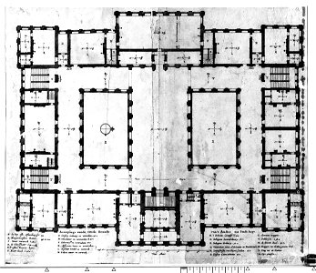
construction drawings in the stadsarchief amsterdam
dutch baroque architecture
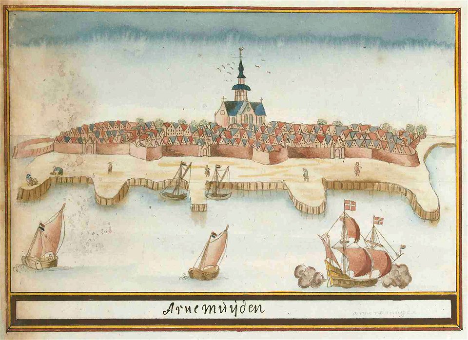
atlas schoemaker-zeeland
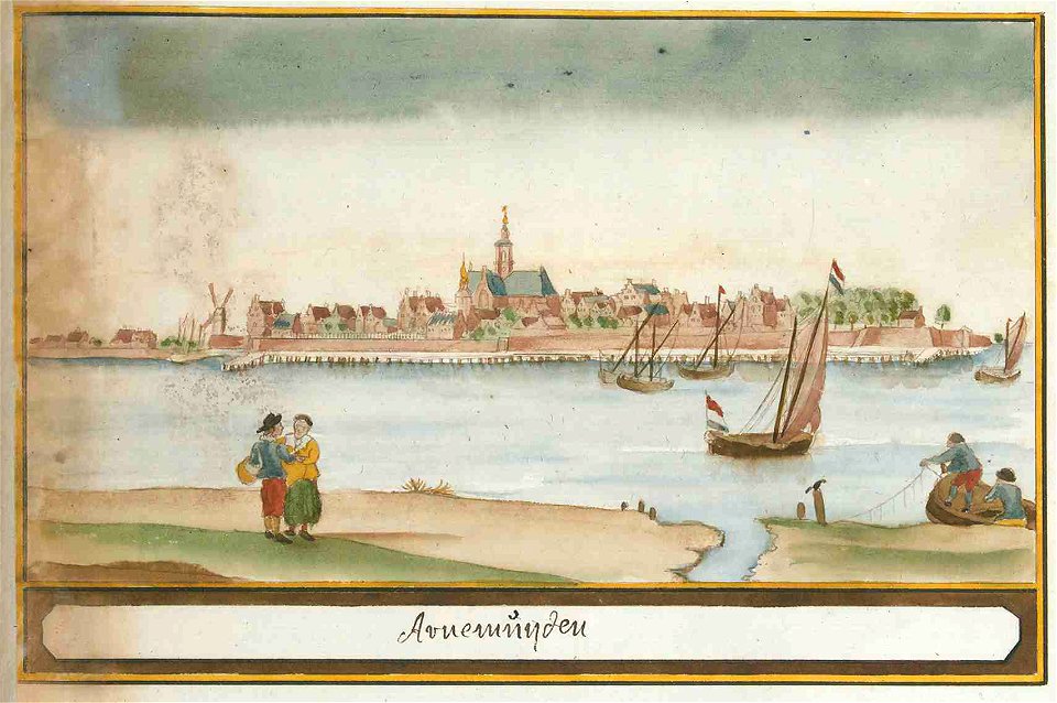
old maps of arnemuiden
joost van geel
de lier
the cruise of the alice may in the gulf of st. lawrence and adjacent waters (1885) by benjamin
maps from the mechanical curator collection
construction drawings in the stadsarchief amsterdam
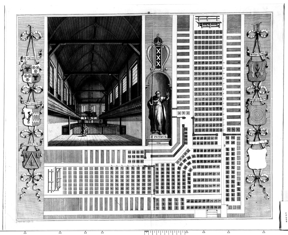
binnengasthuis, amsterdam
maps of country estates in the netherlands
het zegepralent kennemerlant
het zegepralent kennemerlant
hendrik de leth
collection cartographic documents from het utrechts archief
laurens praalder
maps by alexis-hubert jaillot
sanson maps of the holy land
maps from gallica
old maps of paris
old maps of seville
baroque
chorographia britanniae (1741-1742)
18th-century maps of wiltshire
de praecipvis totivs vniversi vrbibvs, liber secvndvs (1612)
maps of oxford by braun & hogenberg
maps of meldorf by braun & hogenberg
maps of heide by braun & hogenberg
de praecipvis totivs vniversi vrbibvs, liber secvndvs (1612)
maps of heraklion by braun & hogenberg
de praecipvis totivs vniversi vrbibvs, liber secvndvs (1612)
maps of konstanz by braun & hogenberg
16th-century maps of crete
old maps of candia
maps by willem and johannes blaeu
beausse
atlas minor gerardi mercatoris (1609)
maps of china by mercator-hondius
de praecipvis totivs vniversi vrbibvs, liber secvndvs (1612)
maps of vejer by braun & hogenberg
de praecipvis totivs vniversi vrbibvs, liber secvndvs (1612)
maps of conil by braun & hogenberg
geographia universalis (1545) in the british museum
german renaissance,northern renaissance
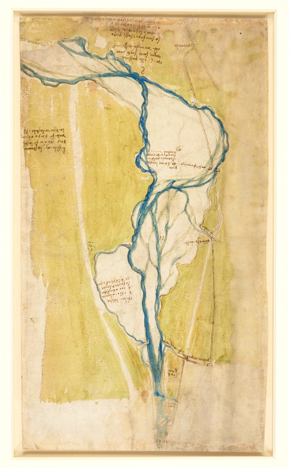
drawings by leonardo da vinci in the royal collection of the united kingdom
high renaissance,renaissance
drawings by leonardo da vinci in the royal collection of the united kingdom
high renaissance,renaissance
picturesque journey to the two americas, asia and africa
lima in the 1840s
illûstrirovannaâ istorìâ ukrainy (1913)
monomakh's cap
maps by jean-baptiste bourguignon d'anville
old maps of roman hispania
high renaissance
pirro ligorio
16th-century maps of crete
old maps of candia
maps of morocco by mercator-hondius
book covers from the british library mechanical curator collection
adolphe giraldon
british library king's topographical collection
map of paris by françois van hoey
carte de la moldavie pour servir à l'histoire militaire de la guerre entre les russes et les turcs - levés par l'etat-major sous la direction de f.g. de bawz... echelle de 10 heures de moldavie, 50... - btv1b53100577d
leonard schenk jansz.
carte de la moldavie pour servir à l'histoire militaire de la guerre entre les russes et les turcs - levés par l'etat-major sous la direction de f.g. de bawz... echelle de 10 heures de moldavie, 50... - btv1b53100577d
leonard schenk jansz.
maps of bristol by braun & hogenberg
maps in the british museum
1690s maps of rhineland-palatinate
maps of east palatinate by sanson
maps from gallica
guides joanne
carte de la moldavie pour servir à l'histoire militaire de la guerre entre les russes et les turcs - levés par l'etat-major sous la direction de f.g. de bawz... echelle de 10 heures de moldavie, 50... - btv1b53100577d
leonard schenk jansz.
carte de la moldavie pour servir à l'histoire militaire de la guerre entre les russes et les turcs - levés par l'etat-major sous la direction de f.g. de bawz... echelle de 10 heures de moldavie, 50... - btv1b53100577d
leonard schenk jansz.
maps of ports and fortresses of the mediterranean by marco boschini (1651)
old maps of kythira
carte de la moldavie pour servir à l'histoire militaire de la guerre entre les russes et les turcs - levés par l'etat-major sous la direction de f.g. de bawz... echelle de 10 heures de moldavie, 50... - btv1b53100577d
leonard schenk jansz.
maps of the islands of greece by marco boschini (1658)
old maps of kinaros and levitha
carte de la moldavie pour servir à l'histoire militaire de la guerre entre les russes et les turcs - levés par l'etat-major sous la direction de f.g. de bawz... echelle de 10 heures de moldavie, 50... - btv1b53100577d
leonard schenk jansz.
maps of the islands of greece by marco boschini (1658)
old maps of the sporades
carte de la mer méditerranée en trois feuilles (dheulland et al.)
18th-century maps of the western mediterranean
maps by pieter mortier
maps from gallica
map of the circle of westfalia by sanson
1680s maps of germany
gustav freytag (cartographer)
old maps of karlovy vary
maps of ports and fortresses of the mediterranean by marco boschini (1651)
bibliothèque nationale de france
maps by willem and johannes blaeu
old maps of quercy
maps of ports and fortresses of the mediterranean by marco boschini (1651)
old maps of heraklion
carte de la mer méditerranée en trois feuilles (dheulland et al.)
18th-century maps of the eastern mediterranean
carte de la mer méditerranée en trois feuilles (dheulland et al.)
old maps of the central mediterranean
dutch 17th-century prints in the rijksmuseum amsterdam
old maps of the hague
œuvres de tony garnier conservées au mba lyon
tusculum (tony garnier)
18th-century maps of the malay archipelago
1790s maps of china
les conquêtes de l'empereur de chine (palace museum)
the battle of khurungui
les conquêtes de l'empereur de chine (palace museum)
the victory of khorgos
les conquêtes de l'empereur de chine (palace museum)
the victory of khorgos
les conquêtes de l'empereur de chine (palace museum)
the battle of khurungui
carte de l'isle de ceylan by guillaume delisle (1722)
eran laor cartographic collection
paintings by jan miense molenaer
baroque
francesco piranesi
old maps of lazio
maps from gallica
guides joanne
maps from gallica
guides joanne
1870s maps of vienna
guides joanne
galleria delle carte geografiche - ceiling
august 2019 in rome
drawings by jens juel in the statens museum for kunst
pen and black marker
18th-century maps of strasbourg
1740s maps of france
dillingen an der donau
baroque
atlas schoemaker-zeeland
old maps of arnemuiden
atlas ou representation du monde universel t. 2 (1633)
1633 maps of africa
atlas ou representation du monde universel t. 2 (1633)
maps by hendrik hondius the younger
atlas ou representation du monde universel t. 2 (1633)
17th-century maps of paraguay
atlas ou representation du monde universel t. 2 (1633)
maps of vicenza
atlas ou representation du monde universel t. 2 (1633)
maps by hendrik hondius the younger
atlas ou representation du monde universel t. 2 (1633)
maps by hendrik hondius the younger
atlas ou representation du monde universel t. 2 (1633)
17th-century maps of silesia
atlas ou representation du monde universel t. 2 (1633)
17th-century maps of peru
atlas ou representation du monde universel t. 2 (1633)
17th-century maps of bermuda
atlas ou representation du monde universel t. 2 (1633)
1633 maps of asia
atlas ou representation du monde universel t. 2 (1633)
maps by jan janssonius
atlas ou representation du monde universel t. 2 (1633)
maps by hendrik hondius the younger
atlas ou representation du monde universel t. 2 (1633)
maps by hendrik hondius the younger
maps of the county of mark
guillaume sanson
atlas ou representation du monde universel t. 2 (1633)
maps by hendrik hondius the younger
atlas ou representation du monde universel t. 2 (1633)
maps of the county of mansfeld
atlas ou representation du monde universel t. 2 (1633)
maps by hendrik hondius the younger
atlas ou representation du monde universel t. 2 (1633)
maps by hendrik hondius the younger
atlas ou representation du monde universel t. 2 (1633)
old maps of groningen (province)
atlas géographique des quatre parties du monde (delisle)
18th-century double hemisphere world maps
atlas ou representation du monde universel t. 2 (1633)
17th-century maps of italy
atlas ou representation du monde universel t. 2 (1633)
maps of sardinia by gerardus mercator
atlas ou representation du monde universel t. 2 (1633)
1633 maps of africa
atlas ou representation du monde universel t. 2 (1633)
maps of the duchy of montferrat
atlas ou representation du monde universel t. 2 (1633)
maps by jan janssonius
5601 - 5700 of 9,296
Next page
/ 93